High temperature in mid-80s in Philadelphia for first day of summer; heat wave starts Saturday

What a difference a day makes! No more storms, heat, and humidity – at least for Friday. Highs will be seasonable in the mid-80s under sunny skies with low humidity. Enjoy because this will be the coolest and most pleasant of the next 10 days. A perfect way to start summer, which finally arrives this evening at 10:41 p.m.
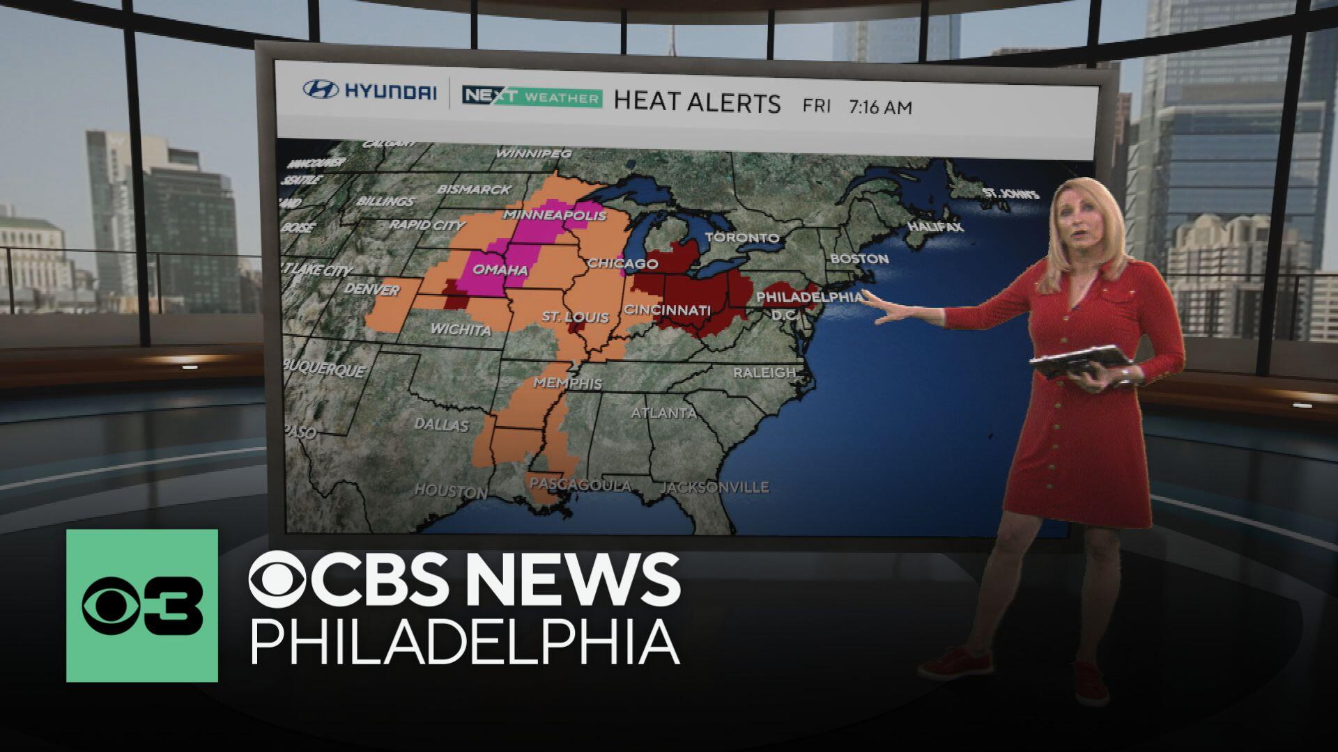
We return to the heat and humidity this weekend as our first heat wave of the year arrives Saturday and lingers through next Thursday! This heat is already being felt across the Midwest, where heat alerts are in place. Maps from CBS News show how these temperatures are much higher than normal.

Philadelphia's Department of Public Health has declared a Heat Health Emergency that will be in effect starting Sunday at noon and lasting until Wednesday at 8 p.m. The emergency could be extended if next week's forecast takes a turn for the worse and the heat wave continues.
, the city has activated its emergency heat programs, including Philadelphia's Corporation for Aging's Heatline, cooling centers, home visits by special field teams and enhanced daytime outreach for those experiencing homelessness.
A full list of cooling centers, spraygrounds and pools in Philadelphia is available .
What is a heat wave?
As a reminder, three consecutive days at or above 90 is considered a heat wave. Saturday and Sunday will be in the low to mid-90s with mostly sunny skies and increasing humidity.
An is in effect from Sunday morning through Wednesday evening in Pennsylvania, New Jersey and Delaware. This type of weather event is the precursor to an Extreme Heat Warning, which will likely be issued by Sunday.

By Monday, we are looking at dangerous heat with highs in the upper 90s to 100 and overnight lows near 80. The feels-like heat index will range from 101 to 107. This dangerous heat will continue through Thursday. At those temperatures, heatstroke and heat exhaustion are possible. The cumulative effect of the heat over six days can lead to additional health problems.
Now is a great time to make sure you have a working air conditioner and a heat plan. Be sure to check on elderly relatives and neighbors and have a heat plan for your pets and kids.

Because of this dangerous heat, a NEXT Weather Alert is in place Monday through Wednesday.
It is likely we will set some new record highs each day and new record highs to lows at night.
No organized storms are headed our way, and it should be dry through next Thursday. However, there is a chance of pop-up storms each day simply because of the heat and humidity.
When was Philadelphia's last heat wave?
For some context, last year's first heat wave ran from June 18-23, and the last one hit at the end of July.
Both topped out at 98 degrees. Our last 100-plus degree day was on July 7, 2012, when we hit 101 degrees. And the longest heat wave on record? A whopping 12 days back in 1901, including two scorchers over 100 degrees.
Here's your 7-day forecast:
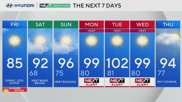
Friday: Happy Summer! High 85
Saturday: Heat wave begins. High 92, Low 68
Sunday: Heat is building. High 96, Low 75
Monday: NEXT Weather Alert for heat. High 99, Low 80
Tuesday: More dangerous heat. High 102, Low 81
Wednesday: Heat wave day 5? High 99, Low 80
Thursday: PM T-storms possible. High 94, Low 77


