Risk of severe weather has diminished across Maryland Thursday evening

All severe weather alerts for Maryland communities have been allowed to expire or canceled early. The risk of severe weather continues to diminish.
Isolated showers and storms remain possible across central Maryland and greater Baltimore through mid-evening. Temperatures gradually cool into the 60s, under a mix of stars and clouds. Areas of dense fog may develop overnight, into early Friday morning.
The First Alert Forecast dries out tonight.
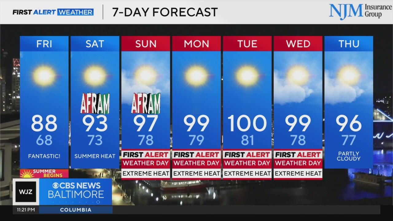
Friday features lots of sunshine and a mostly dry forecast. The day begins with temperatures in the low to mid-60s. Temperatures warm into the lower 80s by noon and peak in the mid to upper 80s late in the afternoon. Humidity levels will be tolerable. A spotty shower is possible across southern Pennsylvania and extreme northern Maryland.
Summer-like weather during AFRAM weekend
A surge of heat builds into the region this weekend, just in time for major outdoor events like the AFRAM festival in Baltimore.
Highs on both Saturday and Sunday will rise into the low to mid-90s, and when combined with elevated humidity levels, heat index values could climb to near 100 degrees by Sunday afternoon. Festival-goers are urged to take precautions, including wearing light-colored and loose-fitting clothing, seeking shade when possible, and drinking plenty of water.
Dangerous heat wave arrives next week
A powerful upper-level ridge of high pressure will establish itself over the Mid-Atlantic, creating a multi-day stretch of extreme heat.
First Alert Weather Days have been issued for Sunday, Monday, Tuesday and Wednesday. Actual high temperatures will flirt with 100° each day. The heat index could easily exceed that threshold, possibly feeling as hot as 105°.
Tuesday appears to be the peak of the heat wave, with some spots potentially experiencing heat index values above 105 degrees. These conditions could lead to heat-related illnesses if proper precautions aren't taken. Residents are advised to limit outdoor activities during peak heating hours, check on vulnerable neighbors, and ensure pets have access to water and shade.
Later in the week, the upper-level ridge will begin to weaken, allowing for slightly cooler - though still hot - temperatures in the 90s. As moisture returns to the region, so will the chance for scattered thunderstorms by late next week, offering a potential pattern change as July gets underway.
Stay with WJZ for continuous updates on the intensifying heat into next week.


