Hotter weather and hazy skies in Philadelphia Tuesday, chasing temps in the 90s this week

If you're ready to embrace the summer vibes, this week's weather is here to help you do just that.
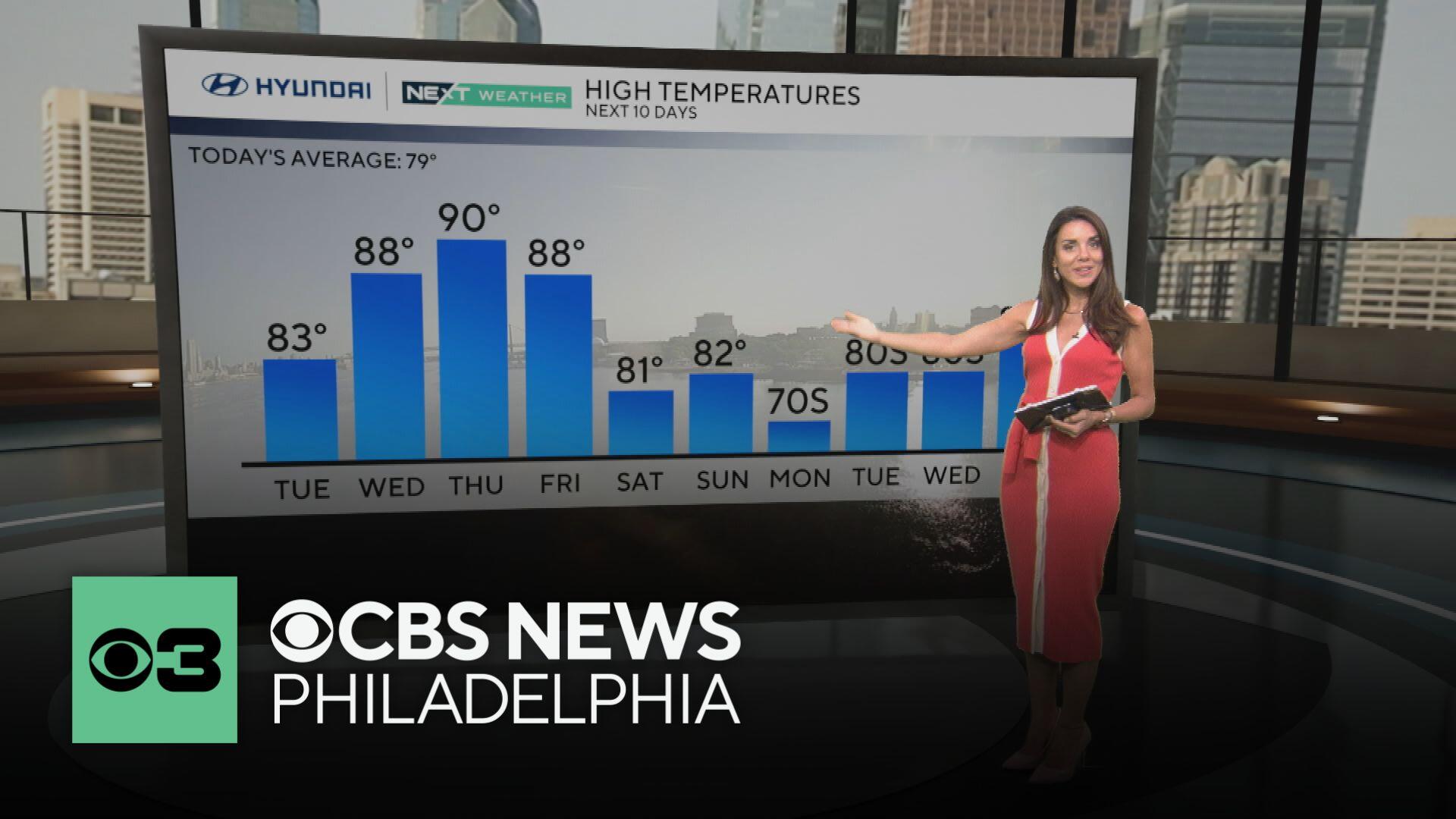
Starting today, expect hazy sunshine as smoke from Canadian wildfires gives the sky a milky filter. It'll be warm, with highs in the mid-80s and lows dipping into the upper 50s.

As we roll into midweek, the heat cranks up—Wednesday and Thursday will be very warm and humid, with highs in the upper 80s and lows in the mid-60s. Perfect for those who love that summer sizzle!
How hot will it get? We will be pushing the 90-degree mark for the first time in 2025. The last time we hit 90 degrees was on Aug. 28, 2024, when the high hit 96 degrees, and we may get to that threshold on Wednesday, Thursday, and/or Friday.

Some smoke in the air may keep the temperature down just a degree or two, but high pressure, sunny skies and southerly winds will all aid in us feeling the warmest temps of the year so far.
When we look at our first 90-degree day, the 30-year average first occurrence in Philly is May 24, so we're over a week behind the average. The warmest we've had all year in 2025 is just 86 degrees, a far cry from where we were last year — when Philly saw its first 90-degree day on April 29.
If we get our first 90-degree day on Thursday, it will be the latest first 90-plus degree day since 2020, when it didn't occur until June 6. The earliest we've ever had a 90-degree temperature was April 7 in 1929, while the latest first occurrence wasn't until July 14 back in 1972.

Philly has never gone a year in recorded history where a 90-plus degree temp wasn't recorded. In fact, the fewest number of days with high temps in the 90s was just five way back in 1889. The average number of 90-plus degree days in Philly is 30.
Also, we are now in June, the start of meteorological summer. We can now look back at the spring season — March, April and May — and see that despite a cool end to May, the average temperature was 3 degrees above normal due to a stretch of warm temps. Our precipitation was above normal as well, helping us to get out of the drought situation we've been in since last fall.
Friday brings a slight cooldown, with highs in the mid-80s and increasing clouds as the day progresses. Saturday, however, turns a bit unsettled - expect a mix of clouds and sun, a drop in temperatures, and a chance of showers and thunderstorms. It's a good day to have an indoor backup plan or keep an eye on the radar if you're heading out. Sunday looks like a winner, with less humidity and plenty of sunshine, highs in the low 80s, and a refreshing breeze.
History of smokey skies in Philadelphia
While this week's smoke is causing an elevated haze in the sky, it's nothing like what we experienced a couple years ago. In June 2023, Philadelphia experienced one of its most extreme air quality events in decades, as smoke from Canadian wildfires blanketed the city.
The haze was so thick that it reduced visibility to less than a mile and turned the sky an orange-red. On June 8, the Air Quality Index (AQI) hit 425, marking the worst air quality in the city since 1999 and making it the most polluted major city in the world that day.
The smoke, originating from wildfires in Quebec, was carried south, affecting large portions of the East Coast. Philadelphia's air quality was classified as "hazardous," prompting health advisories for residents to stay indoors, especially those with respiratory conditions.
The haze even led to the postponement of a Phillies game—the first "smoke out" in the team's 140-year history .
Here's your 7-day forecast:

Tuesday: Hazy sun, warmer. High 83. Low 54.
Wednesday: Getting hotter. High 89. Low 60.
Thursday: Heat is on! High 91. Low 66.
Friday: Cooler, shower. High 89. Low 67.
Saturday: P.m. t-storm. High of 82, Low of 68.
Sunday: Mostly sunny. High 81, Low 64.
Monday: Clouds increase. High 79. Low 62.


