Temperatures warm to summer-like levels across Maryland this week

Meteorological Summer began today, June 1st. By the middle of the week, it'll be feeling much more like summer across Maryland and much of the east coast.
A few clouds continue to bubble up across central Maryland and the eastern shore. Temperatures are cooling through the 60s and into the 50s this evening. Smoke from ongoing Canadian wildfires has been blowing into the United States for a couple days and reached the DMV today. That is why the sky was hazier looking today. However, this smoke is thousands of feet above the surface.
No air quality issues have been reported, locally.
Maryland may see the northern lights on the horizon tonight. The ongoing geomagnetic storm reached G4 - or severe levels - earlier Sunday. That is why the northern lights were reported fairly far south, into portions of the plains and southwestern United States early Sunday morning. There is another shot at seeing the phenomenon Sunday night. However, conditions appear a little less favorable. Also, with so much haze in the sky, they may end up being harder to see even if the Aurora Borealis is spectacular. The best way to see the lights is by going to a dark, rural location and taking long exposure photographs.
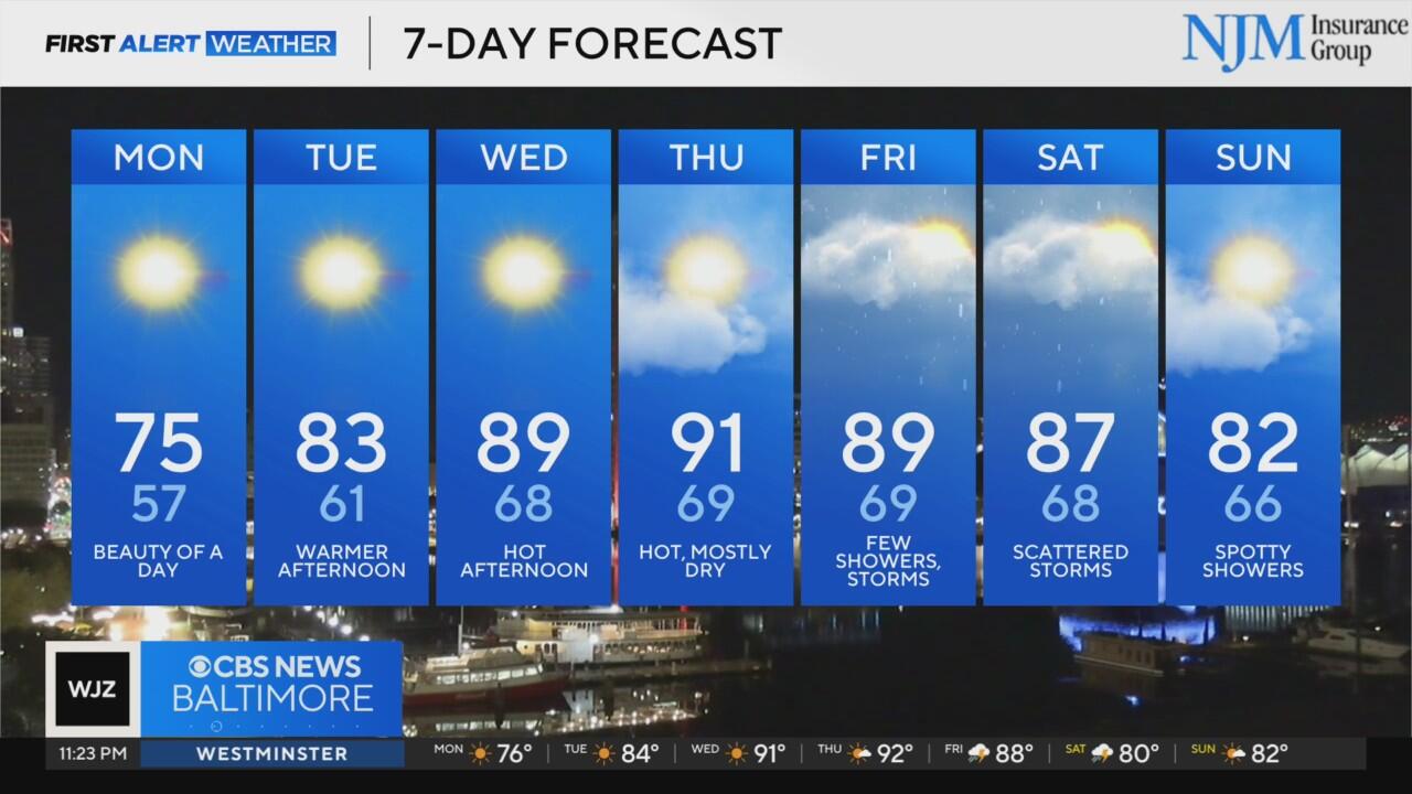
Warmer weather returns to Maryland this week
Monday morning features another round of cool temperatures. Plan on it being in the upper 40s and lower 50s around the Baltimore metro before 8 a.m. Monday. Sunshine sends temperatures into the upper 60s and lower 70s by noon. Temperatures peak in the low to mid-70s by late afternoon. While there won't be that many clouds, some smoke may continue to make the sky look hazy. There should be some improvement in the haze Monday, ahead of what could be a hazy Tuesday.
Tuesday afternoon temperatures peak in the low to mid-80s. We'll soar to near 90° by Wednesday afternoon. Warmer than average weather lingers through the rest of the workweek. It'll feel much muggier by Thursday, as well. Get ready for it.
Baltimore metro rain chances increase late week
While June begins with warmer and drier weather, another storm system approaches our region late this week. Spotty showers are possible across southern Pennsylvania by Thursday. The chance of showers and a couple thunderstorms expands further south to include Maryland Friday. The greatest chance of rain area-wide arrives Saturday. The day doesn't look like a total washout, however.


