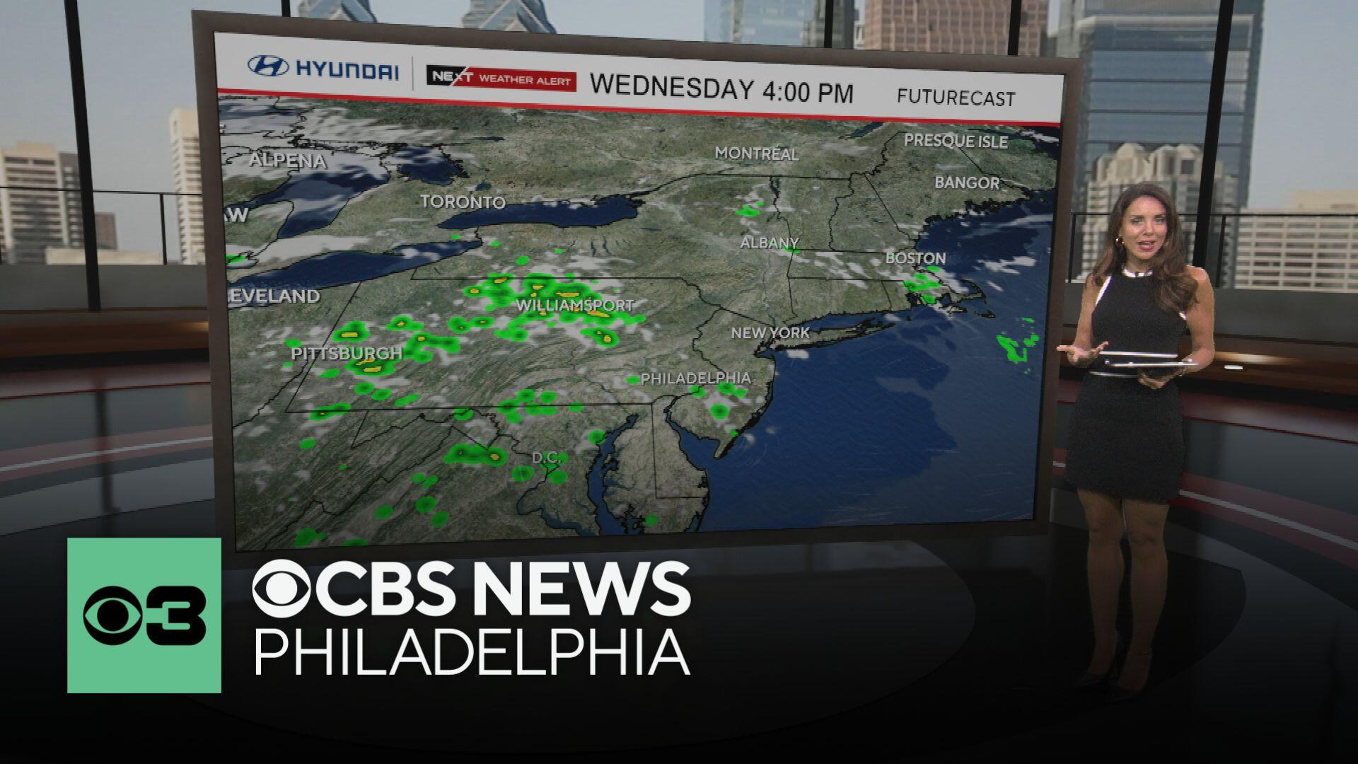
Chance of scattered storms Wednesday in Philadelphia region amid heat wave. Here's the weather forecast.

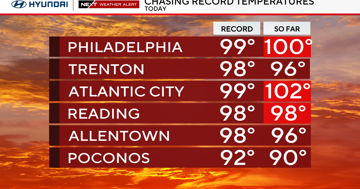
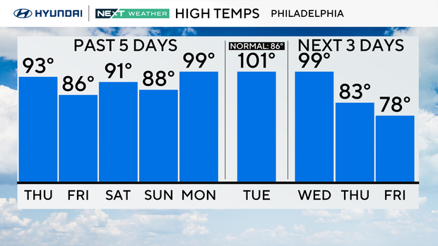
On Wednesday, the final day of the heat wave in the Philadelphia region, the city tied the record high for the day at 98 degrees, which was set in 1952.
Other cities in the region, like Wilmington in Delaware and Atlantic City in New Jersey, broke their records with Wednesday's temps.
Scattered storms could also impact the region on Wednesday night.
The National Weather Service has issued a severe thunderstorm warning until 8:45 p.m. for these areas: Camden County, Gloucester County, Philadelphia County and Delaware County.
If you scroll down, we have more on the forecast for Thursday and beyond, when things turn much cooler and we start to get some relief.
Temperature record broken in Philadelphia on Tuesday
On Tuesday, Philadelphia hit a whopping 101 degrees, breaking the old record of 99 degrees set over 100 years ago in 1923.
In addition, the low temperature of 80 degrees shattered the old record for the warmest low of 75 degrees. The 101-degree temperature was the first in the triple digits in Philadelphia since July of 2012, and only the 29th time that Philly has had a high of 101 or greater.
To put that into perspective, records go back 157 years, more than 57,000 days of record-keeping, and this has only happened 29 times!
The hottest we've ever had was 106 degrees way back in 1918. So yeah, the temps have been a pretty big deal … not to mention extremely dangerous, especially when accounting for the humidity and the feels-like conditions.
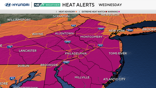
Heat warnings, advisories, air quality concerns
Multiple weather alerts and advisories are in effect because of the heat wave.
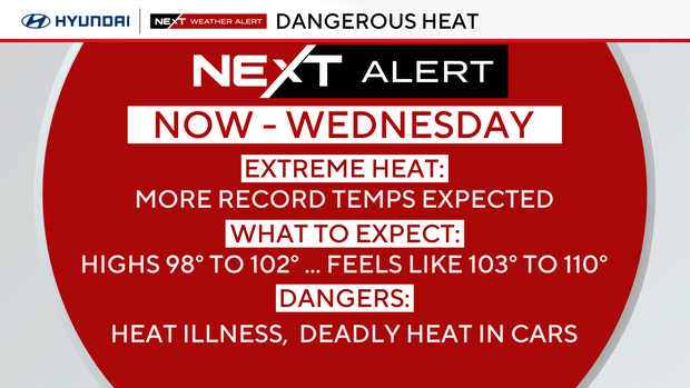
- Extreme heat warning: An extreme heat warning is in effect now until Wednesday evening for all of Pennsylvania, New Jersey and Delaware counties along the Interstate 95 corridor.
- Heat advisory: A heat advisory is also in effect now until Wednesday evening for South Jersey away from I-95, the Jersey Shore, southern Delaware and the Poconos.
- Air quality alert: There is also a code orange air quality alert in effect in the Philadelphia region on Wednesday. The elderly, small children and those with respiratory problems should stay indoors as much as possible. Concerned about the air quality in your neighborhood? Check out to see how conditions are in your area.
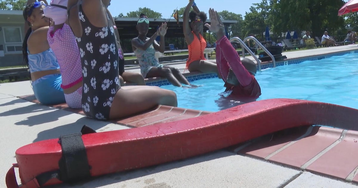
How to stay cool in Philadelphia
The City of Philadelphia's Department of Public Health has declared a heat health emergency, effective now through 8 p.m. Wednesday. The emergency could be extended if the forecast changes and this heat wave continues.
, the city has activated its emergency heat programs, including Philadelphia's Corporation for Aging's Heatline, cooling centers, home visits by special field teams and enhanced daytime outreach for those experiencing homelessness.
A full list of , spraygrounds and pools in Philadelphia is available .
Tips for surviving the heat wave
Make sure to hydrate with nonalcoholic and non-sugary drinks. Spend time in the air conditioning, and if overheated, try a cool shower.
Never leave people or pets in a car; the heat builds quickly, and it can be deadly in minutes. Check on family and friends.
Finally, keep pets indoors or in a shaded area with clean, cool water. Don't walk dogs on the hot pavement; their paws can burn.
Heat wave facts
- Last year's first heat wave lasted from June 18 to 23, and the most recent heat wave of 2024 occurred at the end of July. Both topped out at 98 degrees.
- And the longest heatwave on record? A whopping 12 days back in 1901, including two scorchers over 100 degrees.
Philadelphia weather forecast after heat wave
A big shift arrives Thursday. Throughout the day, a wind switch will take place as a backdoor front arrives from the Northeast. This will usher in a much cooler, stable airmass from the northern Atlantic.
By Thursday afternoon, areas north of the city may see temperatures limited to around 80 just off to the southwest. Ahead of the front, it's in the 90s again. We may see another round of scattered showers and storms. Friday is much cooler and cloudy with highs struggling to rise through the 70s, while it looks a bit cloudy and dreary, it'll be some nice relief from the heat.
Then we have more seasonable early summer weather to look ahead to for the weekend, although the pattern will remain quite unstable with passing showers and storms possible each day.
Here's your 7-day forecast:
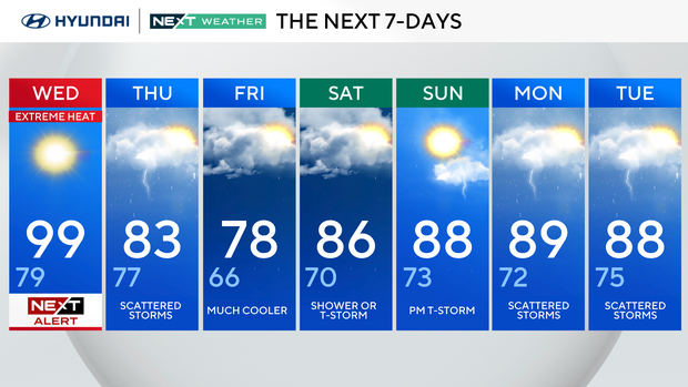
Wednesday: NEXT Weather Alert for extreme heat. High 99, Low 79.
Thursday: Scattered storms. High 83, Low 77.
Friday: Much cooler. High 78, Low 66.
Saturday: Shower or thunderstorm. High 86, Low 70.
Sunday: P.m. thunderstorm. High 88, Low 73.
Monday: Scattered storms. High 89, Low 72.
Tuesday: Scattered storms. High 88, Low 75.