Heat advisory in effect Wednesday, temps could feel like 100 degrees in Philadelphia

Get ready for major changes — after we felt temperatures in the 60s, a huge dome of heat is building in the eastern half of the country, with potential for temperatures to reach the triple digits next week.
But before then, temperatures on Wednesday will climb back into the upper 80s and low 90s, but humidity could make it feel like 100 degrees.
A heat advisory has already been issued for Philadelphia County and the others closest to it, including New Castle County, Delaware, Gloucester, Camden and northwestern Burlington counties in New Jersey, and Delaware County, Pennsylvania from 11 a.m. today until 8 p.m. Thursday.
In addition to the heat, we're looking at a chance of isolated strong to severe storms that could pop up in the afternoon. Parts of our area are in a level 1 risk for severe weather, so we'll keep our eyes on it.
Stormy weather in Philadelphia region
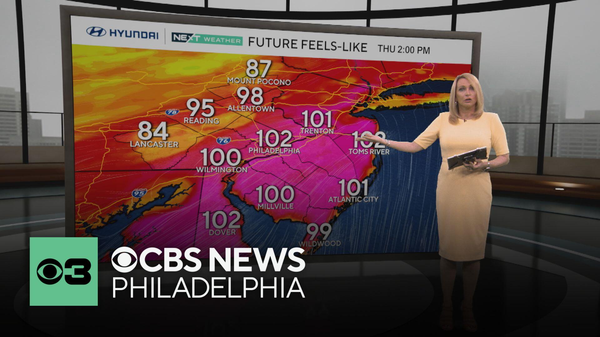
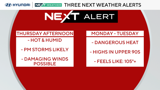
Thursday is a NEXT Weather Alert Day as a stronger line of storms may push through the Delaware Valley during the afternoon and early evening, bringing lightning, heavy rain and the possibility for severe weather, most notably the risk for strong winds.
It'll be another hot and humid day with highs in the low 90s. Timing for the storms looks to be late afternoon west of Philly, with a majority of our area seeing the impacts during the early evening hours, mainly between 5-9 p.m.
This will be quite an interesting way to end spring as summer officially arrives on Friday, and wouldn't you know it, the pattern starts to shift just in time. Friday looks beautiful with a high of 87 in the city.
Get ready for the heat, though. Starting this weekend, we will be entering our first heat wave of the year. That means three or more days in a row hitting 90 degrees or higher, and this stretch could keep going into the following week.
For some context:
- Last year's first heat wave ran from June 18 to 23, and the last one hit at the end of July.
- Both topped out at 98 degrees.
- Our last 100-plus degree day was on July 7, 2012, when we hit 101 degrees.
- And the longest heat wave on record? A whopping 12 days back in 1901, including two scorchers over 100 degrees.
Because of the heat, we'll also be on NEXT Weather Alert Day for Monday and Tuesday as well, tracking feels-like temps of 100-plus degrees.
On Tuesday, we could see the thermometer hit 100 degrees for the first time in nearly 13 years. Stay with your NEXT Weather Team for the latest.
Here's your 7-day forecast:

Wednesday: Hotter, p.m. storm. High 87. Low 69.
Thursday: NEXT Weather Alert for p.m. storms. High 92. Low 73.
Friday: Sunny start to summer. High 87. Low 68.
Saturday: Heat wave begins. High 91. Low 69.
Sunday: Mostly sunny. High 94. Low 73.
Monday: NEXT Weather Alert for extreme heat. High 98. Low 76.
Tuesday: NEXT Weather Alert for extreme heat. High 100. Low 80


