Humid Nights and Stormy Start to the Weekend Across Maryland

A humid and unsettled weather pattern will continue across Maryland heading into the weekend, with multiple chances for rain and thunderstorms before a stretch of drier weather returns next week.
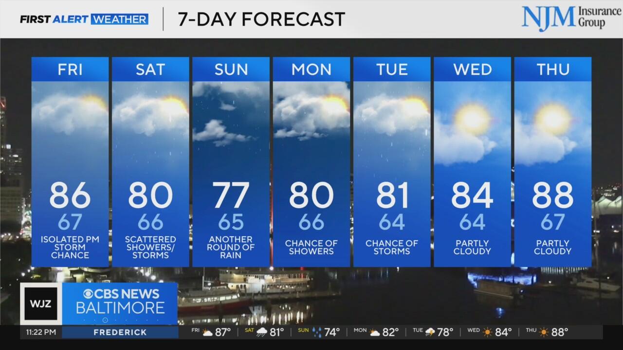
Overnight:
Skies will remain partly cloudy Thursday night, with warm and humid conditions persisting. Overnight lows will struggle to fall much below the mid-60s, particularly in urban areas and along the I-95 corridor. Patchy fog may develop in some of the more rural valleys by early morning, but no significant rain is expected overnight.
Friday Forecast:
Friday will bring another warm and muggy day. Highs will climb well into the 80s across much of central Maryland, with the highest readings likely in areas east of I-95 where sunshine breaks through more frequently. Skies will be partly cloudy for much of the day, and while most of the region remains dry through the morning and early afternoon, a chance for scattered thunderstorms will develop later in the day — mainly west of I-95.
The Storm Prediction Center has placed areas west of a Westminster-to-Frederick line under a Marginal Risk (Level 1 of 5) for severe weather. The primary threats will be isolated damaging wind gusts and heavy downpours. Any storms that do develop will be most likely between 4 p.m. and 9 p.m.
Friday Night into Saturday:
A more organized batch of showers and storms is expected to move through the region overnight Friday into early Saturday morning as a weak front slides through. Rain could be locally heavy in some spots, especially before sunrise on Saturday. Lows will dip back into the mid to upper 60s overnight.
By Saturday, skies will gradually begin to clear from west to east, though scattered showers may linger into the late morning. The best chance for rain will be in the morning hours, followed by drier conditions later in the day. Temperatures will be a touch cooler due to cloud cover and rain-cooled air, with highs hovering near 80 degrees.
Sunday into Early Next Week:
Unsettled weather continues into Sunday, with additional chances for scattered showers and storms. Highs will be a bit cooler in the low to mid-70s thanks to thicker cloud cover.
Monday will bring a brief warm-up, with highs climbing back into the 80s under partly sunny skies. Another round of scattered storms is possible, especially during the afternoon and evening.
Storm chances increase again on Tuesday as another disturbance moves through the Mid-Atlantic. Temperatures will once again reach into the 80s with humid conditions.
Looking Ahead:
By Wednesday, a more stable pattern finally settles in. Sunshine returns midweek with daytime highs staying in the 80s and overnight lows comfortably in the 60s. This dry and pleasant weather is expected to continue through at least Friday.


