Intense heat gradually fades across Maryland by end of workweek

A heat wave begins to subside in Maryland Thursday, after several days of near-record temperatures and stifling humidity.
Everyone is advised to continue taking heat precautions, heat index temperatures approach dangerous levels. Baltimore City has declared a Code Red extreme heat alert through Thursday, June 26.
The forecast continues to gradually cool off and dry out Wednesday night. Earlier storms have diminished.
Thursday features heat and storms across Maryland
Friday Eve begins warm and humid.
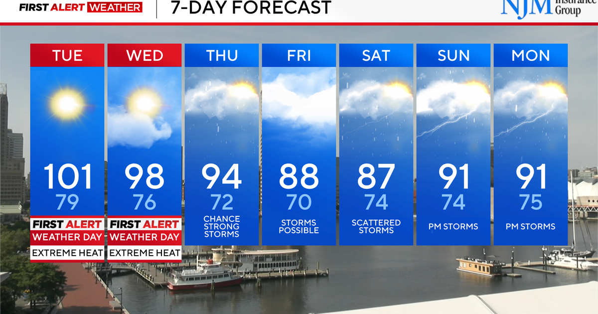
Plan on temperatures ranging from the mid to upper 70s across central Maryland early Thursday morning. Temperatures warm into the mid and upper 80s by noon; peaking in the low to mid-90s by 3 p.m. Feels like temperatures will range from 100° to 105° for most. While this will be a few degrees lower than days past, it'll still be dangerous if you don't prepare and are working outside.
Scattered strong, to severe thunderstorms are possible again Thursday afternoon and evening. The greatest chance of storms will occur between 3 and 11 p.m. A few storms could produce gusty winds and hail. Any storm that develops will produce heavy rain and frequent lightning. Scattered storms will linger late into the evening.
Heat alerts in Maryland
Heat continues to gradually wane across the Mid-Atlantic. Certain alerts have been allowed to expire.
- A heat advisory is in effect for central Maryland from 11 a.m. to 7 p.m. Thursday. Feels like temperatures could approach 105° (and a handful of neighborhoods could surpass that mark) across the WJZ Viewing Area.
Regardless of advisory vs warning, the entire area will be hot and humid.
Staying cool during Maryland heat wave
Here are a few ways to stay safe and healthy while working outside during extreme heat:
- Wear loose-fitting, light colored clothing
- Avoid being in the direct rays of the sun
- Take frequent breaks if you plan to be outdoors
- Drink lots of water, even if you don't feel thirsty. Two liters of water a day is recommended
- Remember pets and the elderly in the heat
- Make sure ceiling fans are circulating counterclockwise to circulate cooler air downward
When will there be a bigger break in the heat?
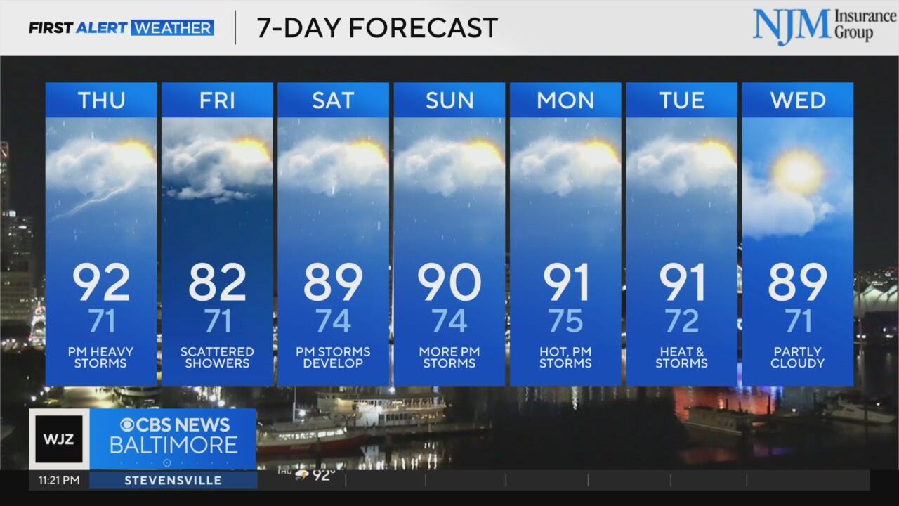
A cold front will sag south Thursday afternoon, sparking scattered showers and thunderstorms that will last well into the evening.
Behind the front, much cooler weather filters into portions of Maryland. Friday will be cooler as the cold front continues to sink south of us. High temperatures may not even reach 80° in some neighborhoods across Cecil County. There is another chance of showers and storms Friday. Rain coverage remains spotty.
Plan on classic summer weather this weekend in Maryland
The upcoming weekend will be seasonably hot and muggy.
Expect variable clouds, with hot and muggy weather. Scattered thunderstorms will develop during the afternoon and evening hours. These storms will be of the hit-or-miss variety. Not every neighborhood will get wet. Neighborhoods that do receive storms could receive locally heavy rainfall, cloud-to-ground lightning and gusty winds.
Temperatures peak in the upper 80s and lower 90s both weekend afternoons. It'll feel hotter when mugginess is factored in.